Monday, November 19, 2018

Misty morning at Skjærsjøen

From Hammeren to Skjærsjøen

I've been bit by the nature adventure bug. Most of my free time is spent walking around the city or forests surrounding Oslo. By foot you can see so many places you otherwise would miss if you were riding in a car, bus, train, etc.

Skjærsjøen lake.

A couple of weekends ago, I braved the clouds, and cool, misty air, to take advantage of my day off from uni. Even though the weather wasn't ideal, it still made for a great daytime hike.

The shore of Skjærsjøen.

I took bus #51 to Hammeren, and then headed north along the forest paths. Eventually I ended up around Skjærsjødammen which is a dam from the 1890s. The dam carries water from Skjærsjøen lake via the Skjærsjøelva, down through the Hammeren hydroelectric power station, and out to Maridalsvannet.  

Looking north across Skjærsjøen.

The paths were so flooded, but I slowly made my way along the lakeside. Looking across the lake I fell in love with Norway all over again. If only I could just get a job hiking around this beautiful country. I feel so happy and at peace when I'm out in nature.

Trail marker.


Since it was a cold, damp day, there were very few hikers out and about. It was kind of nice having the trails to myself, although it was definitely slow going because most of the paths had literally become streams after days of constant rainfall.

Trail back down to Hammeren.

I wouldn't say I got lost, but I had never been in this part of Nordmarka before, so as time passed I began feeling anxious to see trail signs. Soon the sun would be setting and I was becoming slightly more desperate to get back to Hammeren and out of the dense, soggy forests before darkness fell.

A pathway of water.

After trekking through forests, fields, and some valleys where trees had been cut down, I felt relieved when I finally emerged near the Hammeren hydroelectric power station. Fortunately, the main paths in Nordmarka are clearly defined by blue or red markers to help guide through the forests.

Downed tree along the path with its roots growing through the rock.

I didn't take many photos since it was such a wet day and I didn't want to wreck my camera. Yet, despite having my shoes soaked on multiple occasions, I had a great hike and enjoyed getting to explore a new area. Tusen takk!

Sunday, November 18, 2018

Sunshine & Lakes: Trekking in Nordmarka

A Sunny Sunday Adventure 

Øyungsdammen.

It feels like ages since I've seen blue skies. Yet, today the sun was out and shining; making it the perfect day to be out hiking.

Water flowing from Øyungsdammen.

This morning after breakfast I caught bus #51 in the direction of Maridalen and rode up to Skar, which is the last stop on the line.

Øyungen.

At the end of August, I visited Øyungen lake with some classmates. However, we just had a short hike to the lake and rested by the shore. So, this time I wanted to walk around the lake and explore the forest paths.

Photo-op by the lake.

It was pretty chilly this morning, only 37F or about 3C. Despite the cold, lots of people were out taking advantage of the nice weather. It was actually a bit strange to see so many people, because I had been in the area last Sunday when it was misty, yet slightly warmer, and it was just about deserted on the paths, minus several bikers.
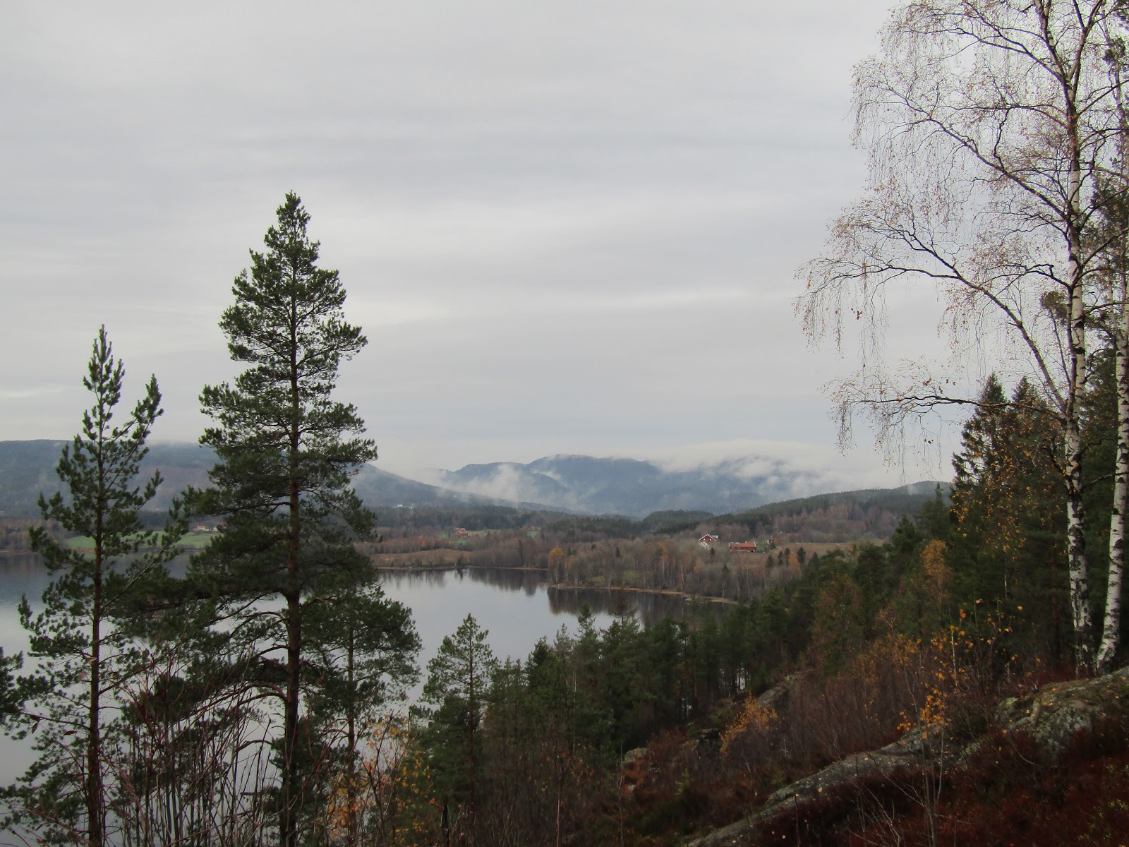
Øyungen.

Fortunately, it's easy to get away from crowds and far enough away from the noises of the city. In the summertime, I think it would be nice to camp along the lake. Many still camp around it now, but at this time of year it's important to be strategic with packing since the nights are cold, and I don't have the camping gear for that.

Eastern side of Øyungen.

The hike along the lake was absolutely beautiful. Sometimes it's a bit slow going because the paths tend to be a bit flooded, but the views are definitely worth the time and occasional soggy shoe.

View of the lake. 

I hiked north along the eastern side of Øyungen following the trail along the side of lake. There are lots of trails heading in the same direction, but I prefer to take the narrow paths with the water views rather than taking the wider, main trails which zigzag through the forests.

Wetland area near the eastern edge of the lake.

As I hiked on, the pathway drew away from the main part of the lake, and went along a smaller channel. Here the lake became smaller and wetlands started to emerge.

Ice and wetlands.

This small portion of the lake was more closed off, making it shadier and colder. Already some of the water near the shoreline had turned frozen over.

The fields of Liggeren gård.

After hiking around the eastern half of Øyungen, the path led up through the forests and past the fields of Liggeren gård.

Trail sign outside Liggeren gård.

When I got to the top of the farm I took a look at the trail sign and decided to head towards Gåslungen gård (1,5km away).

My shadow waving to the camera.

When I go hiking I usually have no plan where I'm going. I just like to walk and see new places. However, on these short days there is one thing I keep in mind; which direction I'm heading.

Frozen pond.

I always try to make sure I make a loop of some sort so that I can head back to Skar or Hammeren, where I know there are bus stops.

Frost around the leaves.

With the sun now setting by 15:40, it's important to have an idea where I am so I can leave enough time to get out to safety. There are no lights along the paths, so when the sun sets, it gets very dark very fast.

Dam made of logs near Gåslungen.

With tree roots and flooded paths, poor lighting definitely doesn't make for safe travel. Plus, as the day went on, it got visibly colder. The more north I hiked the more frost there was on the plants and ground.

River flowing from Gåslungen.

Near Gåslungen gård there was an old wooden dam made of logs, along with a bridge to cross the water flowing down from Gåslungen lake.

Trail sign by Gåslungen gård.

Upon arriving at the farm I took a look at the trail sign to see where I was, and headed in the direction of Hammeren (7.5km away).

Looking out over Gåslungen.

There are several types of paths in the forests of Nordmarka. Paths going along the water, through the forests, and also wide roads for bicyclists and the occasional farmer's car.

Looking north across Gåslungen.

Normally every time I come to the forests things are mostly silent. Just a few birds, but nothing more. 

Gåslungen.

Today, I actually saw a couple of horseback riders, and glimpsed a woodpecker before it flew away. Still no moose, no deer, no fish, and very few birds.

Little island in Gåslungen.

Rain or shine, the lakes are so peaceful and flawless. Oslo is a nice city, but being out in the nature is where I am most happy.

Small island in Rottungen.

Following the trail from Gåslungen, I joined with the main path and headed towards Rottungen. I wish I had time to walk further along Rottungen, but it was about an hour away from sunset and I still had quite a trek down to Hammeren.

Sun setting over Skjærsjøen.

Heading south along the wider bike road to save time, I finally arrived at place I knew. A spot I had ended up in last week when I was exploring Nordmarka. I felt a bit relieved to know where I was since night was coming.

View of Skjærsjøen from the dam.

I passed Skjærsjøen just as it was coming up on 15:30 and took some quick photos before continuing my journey down to Hammeren.

The river flowing from Skjærsjøen down to Maridalvannet.

The walk was getting colder, and it was quickly getting darker, yet lots of bikers and hikers were still out and about.

The moon rising over the forests.

Through the soft pink glow of sunset, the moon arrived high in the sky over the eastern forests of Oslo. At last I made it down to Hammeren right across from Maridalvannet, and waited to catch the bus back home.

Looking towards the southeast side of Maridalsvannet.

It was such a lovely day, and I had a great hike enjoying many new places in Nordmarka!

Map of the hiking route I made.

Tusen takk for a nice Sunday adventure!

Saturday, November 10, 2018

A Walk Around Maridalsvannet

From City to Lake

Dam and bridge over the Akerselva at Brekkedammen park near Kjelsås.

With the end of daylight savings time, the days have quickly gotten much shorter. By 16:15 the sun has set, making the rare moments of sunshine all the more precious.

Path around Maridalsvannet.

Lately, we've had a lot of rainy days in Oslo. Last Saturday, I had to take advantage of the decent weather and daylight by going hiking to check out a new area. It was only 37-39˚ F, so I put on my layers and headed out.

A garden 'deer' near Maridalslvannet. 

I really didn't have any plans where I was headed for the morning. I just started walking and ended up wandering along the Akerselva north towards Kjelsås. I walked through Brekkedammen park and then decided to explore the area around Maridalsvannet.   

Forest pathway.

Normally Brekkedammen park would lead directly to the lake, but currently there is on-going construction to drill a new tunnel into the side of the mountain. Fortunately, there is a path that goes up and around the construction site and turns into beautiful hiking trails.

Looking northwards over Maridalsvannet.

Oslo has 170,000 acres of forest parks in the municipality, meaning there are lots of places a short trip from the city center to go hiking.  It was about a 45 min walk from where I live to Maridalsvannet, but it is also easily accessible by tram or bus. 

The north end of Maridalsvannet.

It was my first time walking around Maridalsvannet, which is the largest lake in Oslo. Maridalsvannet stands for Lake Maridal, and is Oslo's main drinking water source. Everywhere you walk there are signs warning that the lake contains our drinking water, so most all activities are prohibited to protect it.

Photo-op by Maridalsvannet.

I actually didn't even notice any areas where you could go down to the shoreline, but of course there are lots of little streams carrying water down into the lake.  No complaints though, because the views looking down across the lake were breathtaking.

Approaching Sander Gård.

As you follow the trail along you come to Sander Gård, or Sander's Farm. The area was first mentioned in texts dating back to 14th century, where the farm was originally divided between one church and monastery. In 1726, Sander Gård grew into a single farm, and was later purchased by the Nordmarka estate in 1806.

The fields of Sander Gård.

Today, the farm has a central house and a couple of barns surrounded by sprawling fields.  In some areas, the fields run all the way down to the lakeside.   

View of a river that feeds in Maridalsvannet.

Once you pass through Sander Gård, the hiking path disappears and becomes a road. This road then goes the remainder of the way around the lake and back into Oslo. Unfortunately, there are no sidewalks on the road, but quite a few other walkers and bikers travel this way.

View of the lake from Nes Gård.

Just around the corner from Sander's farm is Nes Gård, or Nes' farm.  Just like Sander's farm, Nes' has been mentioned in texts since the 1300s. It too belonged to the church and was also split amongst private owners. In the late 1700s ownership once again changed hands, before becoming part of the Nordmarka estate in the 1800s.

The fields of Nes Gård beside the lake.

To protect Oslo's drinking water, the city purchased the farm in 1923. Since then, several farmers have occupied and worked the land.

Margaretakirkeruinen (Ruins of St.Margaret's Church).

Margaretakirken or St. Margaret's Church was built around 1250. The church is named after Margaret of Antioch, who is the patron saint for pregnancy and childbirth, peasants, exiles, etc. The church was widely used until the Black Death which killed 3/4 of Oslo's population in 1350. During the 1500s, services were held in the church only a few times a year. The last service took place in 1643, leaving the place to fall to ruins.

Side view of Margaretakirkeruinen.

In 1934, archaeologist Gerhard Fischer began the church's restoration efforts. Despite being relatively small and still in ruins, St.Margaret's is considered one of Oslo's best preserved medieval buildings.

Maridalsvannet.

As it was coming up on 3pm, I decided it was time to try to get home before the sun set. I walked 3/4 around the lake, but since it was getting dark and the only place to walk was on the road, I didn't want to take my chances by walking much further. I had a little walk down to Hammeren where finally I found a bus stop that would take me back into Oslo.


River flowing down from Hammeren towards the lake.

It was a long, but beautiful walk. If only they had trails along the western side of the lake I would have walked the remainder of the way home. As I was waiting for the bus, I took a look around Hammeren which also has lots of hiking trails. Can't wait to explore more!